Cars submerged after heavy rain and winds sweep across UK
Spread the love
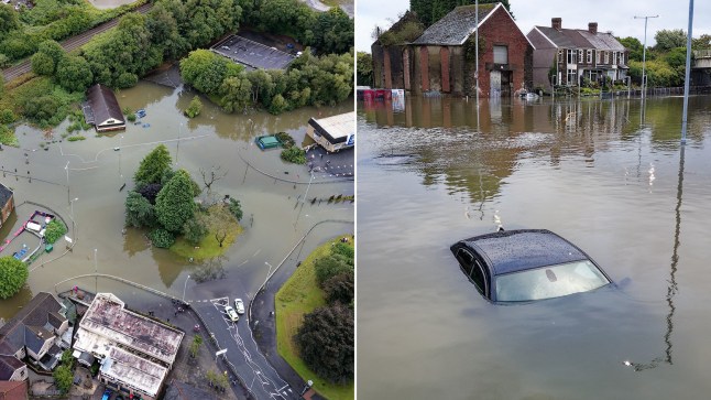
Severe Flooding Brings Chaos to Wales as Heavy Rain and Strong Winds Batter UK
Wales, UK – Severe flooding triggered by relentless rainfall and powerful winds has submerged major roads across Wales, disrupting transport, damaging infrastructure, and leaving communities struggling to cope.
In Swansea, the Cwmbwrla roundabout has become one of the worst-hit locations. The busy junction was completely waterlogged, forcing its closure “for some time,” according to local authorities. Photographs from the scene showed vehicles half-submerged, with some residents resorting to paddleboards to navigate the flooded road.
Elsewhere, South Wales Police confirmed they were responding to incidents across the region, including severe flooding on Goetre Fawr Road in Killay, which has now been closed to traffic.
Warnings Issued Across Wales and England
Natural Resources Wales has issued three flood warnings and seven flood alerts, urging residents to remain vigilant. Across the border, the Environment Agency has also raised two flood alerts in England, one for the River Rea in Birmingham and another for the River Sow and River Penk in Staffordshire, meaning flooding remains possible in these areas.
The Met Office has placed a yellow weather warning for wind covering the whole of Wales and most of England until 6pm on Monday, September 15. Gusts of up to 70mph are expected in coastal and exposed areas, with forecasters warning of public transport disruption, power outages, and hazardous travel conditions. Coastal communities have been particularly cautioned against the risk of large waves and sea spray.
Authorities Urge Caution
Emergency services have appealed to drivers to take extra precautions, especially near the coast, and to consider delaying or rerouting journeys where possible.
“Tonight is when the winds start ramping up,” said Met Office meteorologist Kathryn Chalk, warning that the area of low pressure driving the storm system would intensify into Monday before conditions improve by Tuesday. However, she noted that another system could sweep across the country on Wednesday, September 17, potentially bringing further disruption.
Despite the severity of the conditions, the Met Office has decided against naming the storm. “Obviously, we are in meteorological autumn now—it’s the sort of weather that we do expect at this time of year,” said spokesperson Graham Madge.
Local Impact
Communities across South Wales have already begun feeling the brunt of the storm. Shops and small businesses near low-lying roads have reported water damage, while public transport services in some areas have been suspended or delayed.
While some residents found a moment of humor—such as those spotted paddleboarding through Swansea’s flooded roundabout—others expressed concern about long-term infrastructure damage. “It’s not just an inconvenience, it’s dangerous. If this continues, people’s homes and livelihoods could be at risk,” one resident told local reporters.
What’s Next
Conditions are expected to improve by Tuesday, September 16, but forecasters remain cautious, warning that the midweek system could bring another wave of strong winds and heavy rain. Authorities continue to monitor river levels and coastal areas closely, with further warnings possible.
For now, residents across Wales and parts of England are being urged to remain prepared, avoid unnecessary travel, and stay updated through official channels.


")